


GeoPDF originated not just as a file format but as part of LGI’s broader LGIView system—a comprehensive platform that integrated map creation, metadata, and interactive PDF features, leading to TerraGo’s 2005 spinoff to commercialize this geospatial technology.
Author: mabasil
TerraGo Welcomes Charlie Nobles to Leadership Team to Further Strengthen Utility Operations and Technology Expertise

TerraGo Technologies today announced that Charlie Nobles has joined the company’s leadership team as Vice President of Sales, bringing decades of applied technology and utility operations expertise.
The Evolution of GeoPDF: U.S. Government Initiatives in Geospatial Mapping
From the pioneering SBC project and LGIView to NGA’s advanced requirements for “full geo” capability, this piece traces the development of GeoPDF standards, software adoption across key agencies, and the birth of TerraGo.
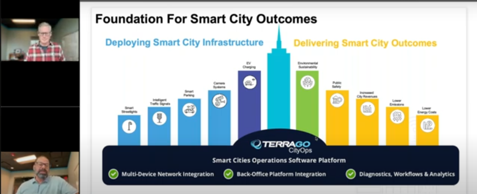
7 Biggest Challenges – Smart Cities Connect Webinar
In this follow-up webinar, BAE Systems dives deeper into the capabilities and updates of GXP360 for 2024. The session provides an in-depth look at new features, user tips, and best practices for maximizing the use of GXP360 in geospatial data analysis and visualization. Experts also address user questions, offering solutions and insights to enhance workflow efficiency.
Where Maps Come Alive: The Birth of the GeoPDF
TerraGo turns 20 this year. To mark the occasion, we’re launching a series of articles exploring the history of GeoPDF and the software tools that produce, modify, and consume GeoPDF maps. In this inaugural post, we look at the early use of Portable Document Format (PDF) files and custom-built software systems that delivered geospatial applications—or GeoApps—to end users.
Bright Lights, Safer Streets in Philadelphia

When it comes to public safety, lighting the way—literally—can make a powerful difference. A new study evaluating the Philly Streetlight Improvement Project (PSIP) shows just how impactful these programs can be.
TerraGo Announces New Director of Services to Further Expand Industry Expertise and Transform City and Utility Operations

Eric Barger brings over two decades of utility technology and operations management experience with Exelon Baltimore Gas & Electric (BGE)
CPS Energy Streetlight and Smart City Project Wins Smart 20 Award

Dalkia Energy Solutions is providing comprehensive street lighting support services to CPS Energy, and utilizing TerraGo’s software platform, to manage streetlight operations, evaluate emerging technologies, and deploy smart city solutions.
How Smart Cities are Engaging the Community

Streetlights are key to community safety and security, yet reporting an outage can still be a frustrating process. And while smart LED streetlights are a step forward, simply upgrading lights doesn’t automatically streamline operations or connect residents with these improvements.
Customer Story: Improving Outdoor Lighting Operations with Georgia Power

Georgia Power is using TerraGo’s software platform to re-engineer outdoor lighting operations, better serve communities, reduce their carbon footprint, and boost efficiency.